Named after the star nearest to the throne of God in LDS scripture, Kolob Creek (Kolob Canyon) is a deep and remote tributary of the Zion Narrows that has several long and dramatic slot sections. While most canyoneers are focused on the upper technical section of Kolob Creek and its dramatic 100 to 150-ft rappels and ice-cold pools, the route described here is for the lower section of Kolob Creek. The last 4 miles of this canyon before the junction with the Zion Narrows make for a beautiful semi-technical adventure, but navigating the logistics and dealing with the approach hike will keep most people away.
| Rating: Strenuous semi-technical canyoneering |
| Access: Start at the West Rim Trailhead, end at Temple of Sinawava (the 9th and final stop for the Zion Canyon Shuttle). Car spot or private shuttle required. |
| Time Required: 11-16 hours (2 days recommended) |
| Length: 14 miles (roughly 3 miles approach, 4 miles in Kolob Creek, and 7 miles in the Zion Narrows) |
| Elevation Change: 3000-ft total descent (roughly 1800-ft down the approach hike and MIA, gradual 1200-ft descent down Kolob Creek and the Narrows) |
| Technical Challenges: Downclimbing numerous obstacles in a remote canyon, a few swims in cold water, 1-3 short rappels, navigating the convoluted and steep MIA route. |
| Equipment Needed: 50' rope, climbing harness and rap device, a run of webbing (useful for handlines), drybag, overnight gear, GPS and map for navigating the approach hike and MIA route. |
| Seasons: Summer and fall. Descents are not permitted while the Zion Narrows are closed during the spring runoff (typically April to May). |
| Permit Required? YES, Zion wilderness permits for Kolob Creek and Zion Narrows campsite are required. Permission to cross private property is also required. |
| Flash Flood Warning: Do not do this canyon if there is a threat of rain. |
WARNING: Descending this canyon involves downclimbing many obstacles in a remote canyon environment as well as 1-3 short rappels. Navigation along the approach hike can be tricky and intimidating. This route is not suitable for casual hikers.
 |
Lower Kolob Creek Map #1: West Rim Trailhead to MIA Route. |
|
Lower Kolob Creek Map #2: MIA Route to Zion Narrows. |
|
Lower Kolob Creek Map #3: Zion Narrows to Temple of Sinawava. |
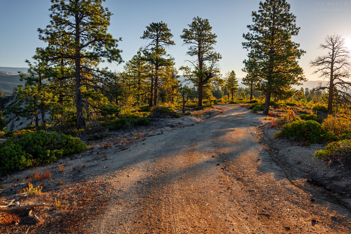
To get to the West Rim Trailhead, starting from the town of Virgin, drive roughly 19 miles up the Kolob Terrace Road and turn right at the well-signed dirt road turnoff for Lava Point. Once in the NPS boundary, turn left at the next road junction. The final stretch of dirt road down to the West Rim Trailhead is usually accessible to non-4WD vehicles, but it can be treacherous in wet or muddy conditions. You might also consider paying one of the Springdale outfitters for shuttle service to avoid having to pick up your vehicle later.
From the small parking area at the West Rim Trailhead, go past the gate and hike the dirt road east. At roughly 1.1 miles at the first road junction, stay left (east) and soon after at the second junction, go right (southeast). Soon after, you will reach the private property boundary with a big sign that says "No trespassing if you have not executed a recreational license agreement with the property owner." (Be sure to have your signed form with you on your phone just to be safe.)
The old dirt road continues east along the ridgeline for another .5 miles before turning south down a steeper hill. At the bottom of the hill, head left (northeast) in less than .1 miles, the start of the MIA route will be on the right. The start of this trail is not marked and you would not notice it if you weren't looking for it. It looks more like a line of erosion from waterflow. Coordinates: 323811E 4138724n (UTM NAD27).
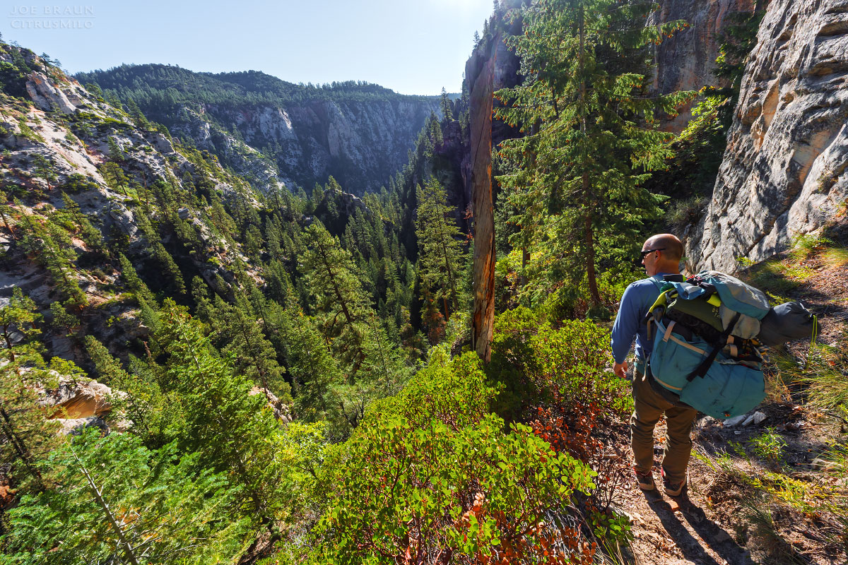
The MIA Route from the upper plateau down into Kolob Creek is a steep and challenging trail-of-use that can be difficult to follow. The “MIA” originally got its name from LDS’s “Mutual Improvement Association” using the route for youth group outings, but the more tongue-in-cheek “Missing-In-Action” acronym certainly plays into the route’s infamous difficulty. Most canyoneerers use the MIA to exit up from a day in Kolob Creek and Boundary Canyon, but we’re going to use it the other way to descend more directly into Kolob Creek. The MIA is admittedly a steep and difficult “trail” and it’s easy to get off track or confused, so allow plenty of time.
From the dirt road, follow the MIA trail downhill through the trees and soon you will get a good open view of the canyon below. Yes, we're heading to the bottom of that! The initial open section is the most intimidating part of this route as you head down through the loose debris and scree. It is easy to lose sight of the trail-of-use, especially at spots with fallen trees, but look around carefully and you should see signs of human foot traffic. The trail tends to hug the right (south) slopes. Soon enough, you will make your way to the bottom of the overgrown MIA Canyon.
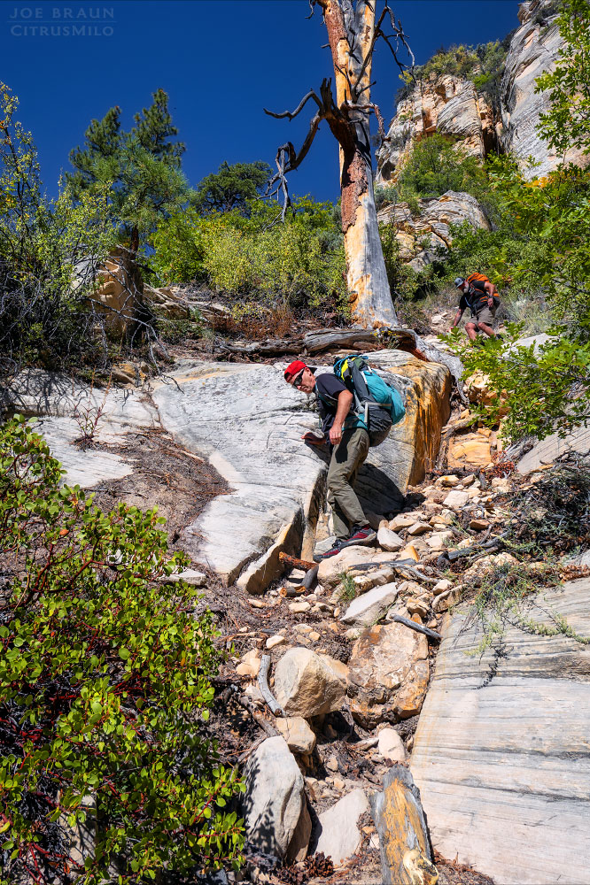
Hike down the pleasant wash for only .1 miles until the canyon slots up. (Note: Going straight down the canyon would involve a few rappels up to 80 feet. We're trying to do the hiker's route, so we're going to bypass this slot section by going up a ridge pass to the north.) Backtrack from the start of the slot and hike north up a little overgrown drainage. Soon enough, the views will open up and you'll see the solid rock of the ridge pass high above. Hike up to the pass and then head east along the base of the white sandstone cliffs. You will have to fight the overgrown forest and manzanita a little bit. Make your way to 324403E 4138679N (UTM NAD27).
From this point, we start our descent back to the bottom of MIA Canyon. Head southeast down the slickrock debris field and trail-of-use. A few cairns will show the way. When you reach dirt and manzanita, look for a trail-of-use that heads down the slope to the right and back into the bottom of MIA Canyon. Within a few seconds, we arrive at the top of a tall dryfall overlooking Kolob Creek below. Look for a bypass trail that heads into the forest to the north and follow it down. Once you're standing in Kolob Creek, it's time to celebrate; that .6 miles of the MIA route is no easy hike!
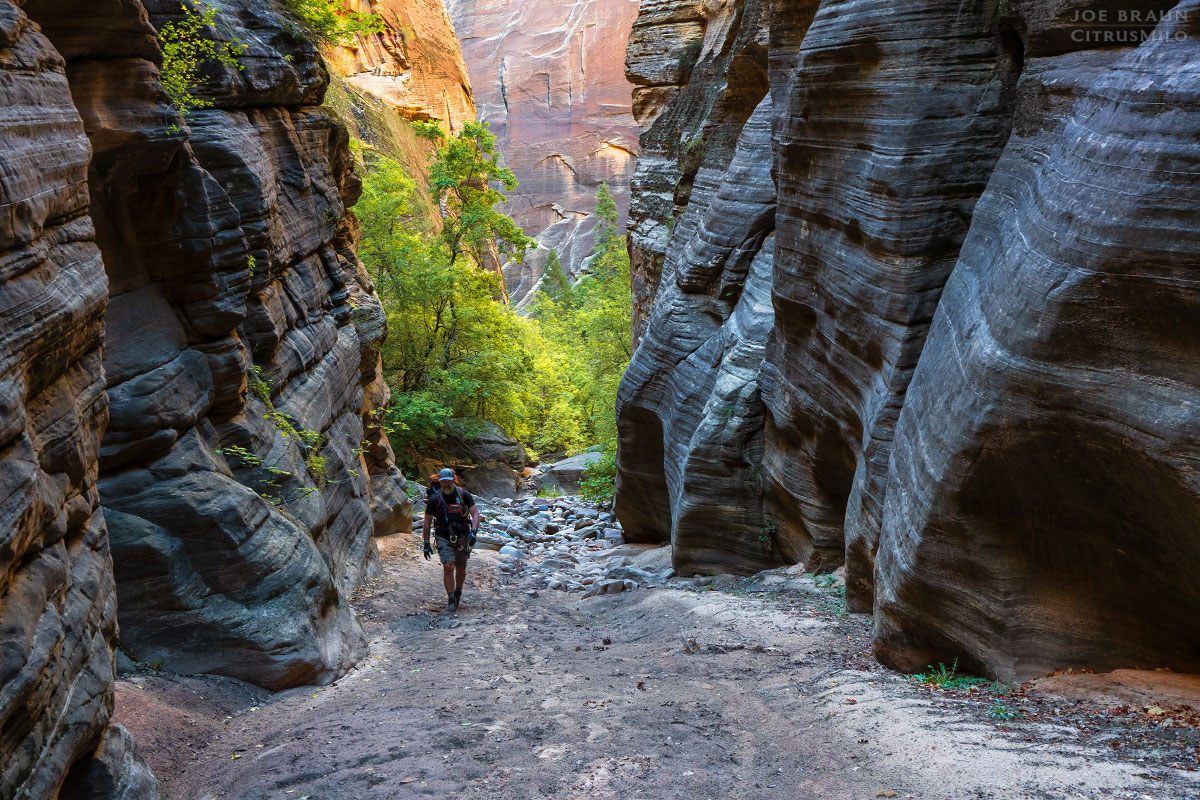
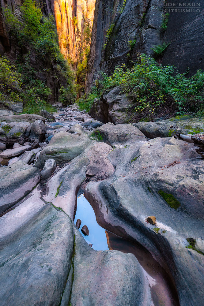
The hike though lower Kolob Creek from the MIA junction to the Zion Narrows is a bit under 4 miles and may take 3-5 hours depending on the condition of the obstacles that you encounter. The scenery is similar to upper sections of Orderville Canyon, but it’s slightly more rugged due to the numerous boulders that are scattered throughout.
Roughly 20 minutes from the MIA is Boulder Obstacle #1: a 20-ft drop with a bolt in the right (west) wall. Perhaps in wet conditions a rappel and swim might be necessary, but we were able to downclimb the boulders on the left without giving it much thought. Around the next few corners, the scenery gets more dramatic with the canyon walls towering in the distance.
Soon enough we get to Boulder Obstacle #2: another 20-ft tall boulder with a large pool underneath it. We downclimbed a log on the right side of the canyon, but if not present, it would be easy enough to rig a short rappel off of the numerous logs or boulders just behind the drop.
The next stretch of canyon is quite beautiful with several sections of narrow dark slots interspersed with more vegetated open sections with minor obstacles to scramble down. Roughly 30 minutes from the last big obstacle is Boulder Obstacle #3: a large boulder wedged at the start of a narrow corridor filled with water. An old piton anchor in the right wall and a sketchy bolt on top of the boulder are present. The rappel is roughly 25 feet followed by a long cold swim out of the corridor.
The final sections of Kolob Creek have fewer obstacles and make for easier hiking, but the dramatic scenery doesn’t quit. If you’re good on time, take it slowly and allow yourself to soak it all in. Soon enough, the remote canyon fun is over and you’re at the junction of the Zion Narrows.
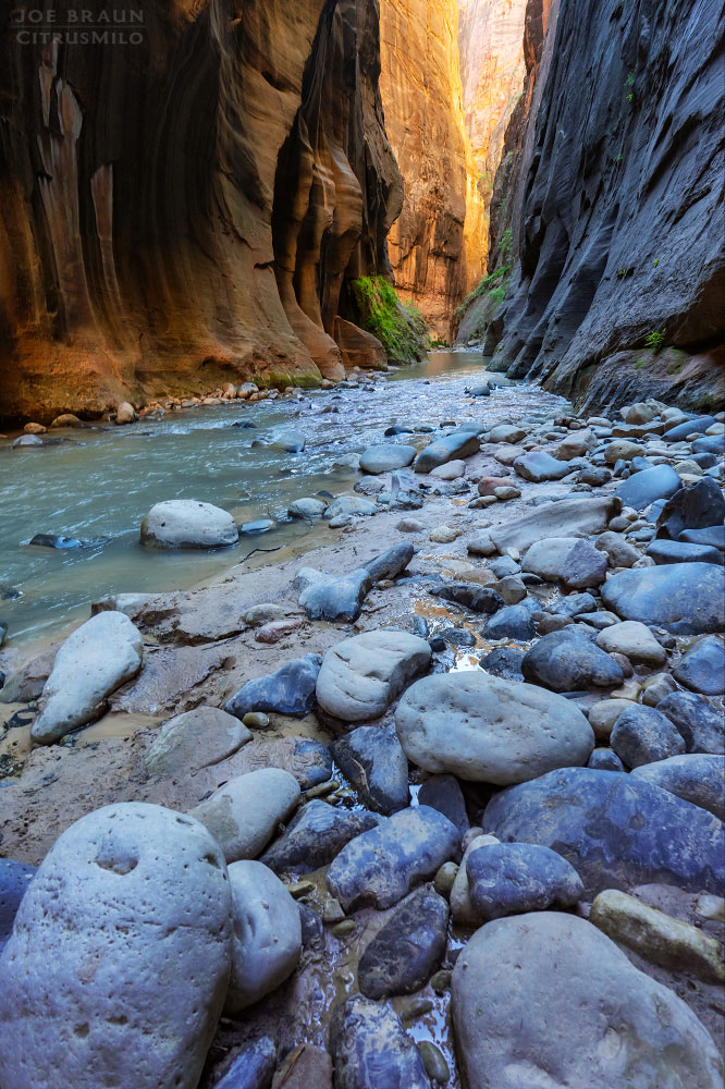
From the junction of Kolob Creek and the Zion Narrows, it’s roughly 7 miles of river hiking to the Temple of Sinawava. After hiking in a mostly dry canyon all day, it’s a bit of an adjustment to hiking in flowing water, especially if water levels are high. Hiking poles or a hiking stick can be very beneficial. If you have a permit for one of the Zion Narrows campsites, be on the lookout for the yellow campsite markers for campsites 6 through 12. Campsite 6 is located at the mouth of Kolob Creek and campsite 12 is just upstream of Big Springs, the official turn-around spot for Narrows bottom-up dayhikers.
The final hike out the Zion Narrows from Big Springs to the Riverside Walk and the Temple of Sinawava is pretty straightforward and should take roughly half a day at a moderate pace. After spending the previous day in the wilderness isolation of Kolob Creek, it will be a bit of a shock to the system when you start seeing dayhikers coming toward you in the Narrows. And of course, near the end of the hike, you will encounter citylike crowds of people. It’s all good though; everybody deserves a chance to experience nature in a way that works for them.
I first read about this route in Brereton and Dunaway’s classic old book “Exploring the Backcountry of Zion National Park.” While hiking down the MIA route may not be as exciting as coming down the technical section of upper Kolob Creek or Boundary Canyon, I find this route to be quite rewarding, navigating difficult terrain in a steep and remote canyon. And of course, the scenery in the lower four miles of Kolob Creek are extraordinary and very few people get to experience it.
Please note: This web site and all images on this site are the property of CitrusMilo Adventures ©2025. Unauthorized public or commercial use of any of the images or text on this website without explicit permission is strictly forbidden.


