
A Long Sandy Road to the Barracks:
Located roughly 2.8 miles east of the Zion National Park border, "Poverty Trail" is a nickname for an old cattle trail that heads south from Route 9 into BLM land to reach the East Fork of the Virgin River. These days, it is part of a network of ATV tracks that wander around the edge of the White Cliffs with the final mile being limited to foot and horse travel only. This route may be considered a shortcut versus hiking in from Mt. Carmel Junction, but it is still a long trek and admittedly the least interesting route into the Barracks. Nearby Poverty Wash is a remote drainage worthy of exploring that adds time and difficulty to this approach hike.

Hiking Poverty Trail:
Roughly 2.8 miles east of the Zion National Park border along Route 9, Poverty Trail is a meandering dirt road that heads south into the White Cliffs above Parunuweap Canyon. It is roughly 7.5 miles to the bottom of Parunuweap Canyon, but while regular vehicles can typically handle the first mile, things quickly get rough as the track descends and crosses over the Poverty Wash drainage. Driving beyond in anything less than a high-clearance 4WD vehicle is not recommended.

Continuing south beyond the edge of the White Cliffs, the pitted road will stop all but ATVs and hikers. Take care with your vehicle and don't press your luck; this would be a horrible place to get stranded.

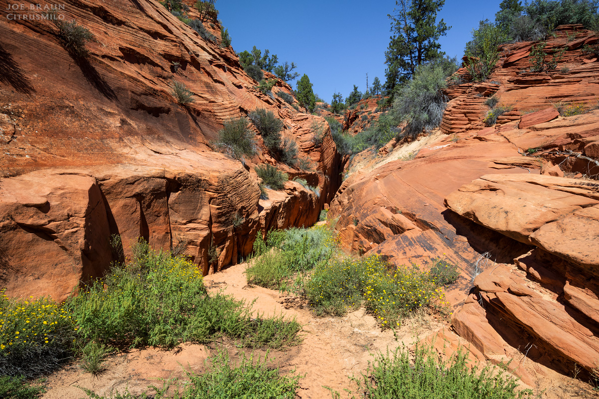
Once clear of the White Cliffs, the track turns to deep sand and starts heading west. Look for a roadside trailhead of sorts on the south/left side with an "Entering Wilderness Study Area" sign. This is the final leg of Poverty Trail. While this used to be an ATV track back in ye olden times, it is now only open to hikers and horseback riding. IMPORTANT: If your intended route is "Poverty Trail", do not mindlessly follow the main track; keep an eye out for the wilderness sign. This last mile heads south and is marked by a sandy and steeper final descent down to the river.

If traveling by foot, it would take an average hiker roughly three hours to get to the bottom of Parunuweap. If hiking out, allow much more time as the uphill in deep sand of the lower few miles makes for slow going. There are, however, no climbing or scrambling obstacles along this route.

Aside from being an alternate start to hiking Parunuweap from Mt. Carmel Junction, this route should be kept in mind as a possible emergency escape route should you need to abort a hike through Parunuweap or find a dependable way out of the canyon. For more information on hiking this area, please see the descriptions for The Barracks and Mineral Gulch.
Descending Poverty Wash:
While hiking Poverty Wash is usually done "from the bottom" to visit the lovely Poverty Grotto during a thru-hike of the Barracks, it is possible to do a top-down descent of this mostly non-technical canyon. One can hike the Poverty Wash drainage all the way from the initial ATV road crossover near Route 9, but if you are hiking Poverty Trail, instead of taking the final leg south to the East Fork, continue west on the 70/K1600 ATV road for another 1.8 miles. The track is very easy to follow but the section of uphill in deep sand can be a bit of a grind.

Once you reach Poverty Wash, leave the road and start hiking down the drainage. Similar to nearby Misery Canyon and Mineral Gulch, the drainage alternates between open sections and short little slot sections. There are typically no major obstacles in the upper sections of the canyon, but there are a few downclimbs over wedged logs and boulders. (Hiking back up the drainage could be difficult because of some of these obstructions.)
The most notable obstacle is a dryfall just above Poverty Grotto where the drainage cliffs out at an awkward 60-ft drop into the canyon below. The easiest way around is to hike up the ridgeline on the left (east) side of the canyon to bypass the slot. Roughly a quarter of a mile south is a class 2/3 scramble down a dirty chute that gets you back into the drainage just around the corner from the slot section. Careful route finding is required. Be sure to explore up the slot to the grotto before you continue downcanyon.
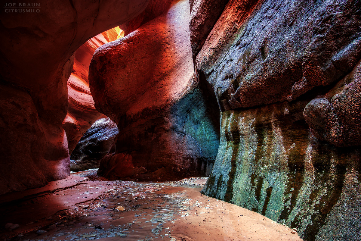
Alternatively if you want to stay in the drainage, you can make your way down the right side and scramble down a convenient little ramp. This downclimb can be intimidating to some, but a small tree growing at the edge of the ramp can be used for a handline or a really short rappel down to the canyon floor. Just around the corner is a 40-ft rappel into the grotto. A single old bolt is positioned just above the drop, but if that seems too sketchy, plenty of anchor-building materials are present just upcanyon.
Once down in the cavelike grotto, enjoy the beautiful riparian slot section that sadly ends after only a few moments of hiking down the canyon. Continue hiking down the lush open lower section of Poverty Wash until you hit the junction with the East Fork of the Virgin River.


