

Hiking the West Rim Trail:
The West Rim Trail is one of the classic backcountry trails in Zion: a 15-mile long trail along the upper west plateau that connects Lava Point (the highest point in Zion) with the Grotto Trailhead in Zion's popular main canyon. Most visitors to Zion are familiar with the lower section of the West Rim Trail that leads to the famous Angels Landing hike, but those willing to hike further up the trail will be treated to more outstanding views as the clever trail makes its way through the wondrous sandstone formations. Those who have enough time and strength to make it all the way up to the upper plateau will also be treated to grand views of the Great West Canyon.

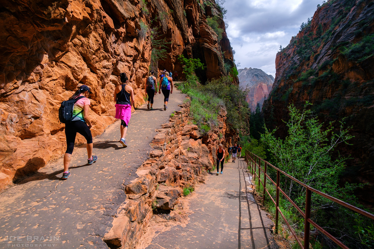
The Grotto to Scout Lookout:
The West Rim Trail starts at the Grotto Trailhead, the 6th stop for the Zion Canyon Shuttle in Zion's main canyon. Cross the hiker's bridge over the Virgin River and take the paved trail north as it follows the banks of the Virgin River. The trail then starts its aggressive ascent by zigzagging up the west wall into Zion Canyon and works its way into the narrow hanging side canyon known as Refrigerator Canyon. The section of trail just before entering this hanging side canyon is the steepest in the park.
Once in Refrigerator Canyon, hikers are treated to cooler temperatures and shaded canyon scenery. Soon enough, we reach an amazing bit of 1930s CCC engineering: Walter's Wiggles -- a set of many compact switchbacks that takes the trail all the way up to the top of the ridge above Refrigerator Canyon.

The trail levels out a bit and soon enough we arrive at Scout's Lookout -- a nice little viewpoint where we can get a good look at Angels Landing and Zion Canyon below. At this spot, most people will choose to hike the thrilling and popular Angels Landing trail, but we will continue up the West Rim Trail for less crowds and beautiful underrated scenery.

Scout Lookout to the Upper Plateau:
As the trail continues its uphill journey north away from Angels Landing, be sure to look behind you and to the east (right) for spectacular views down into the main canyon. (Warning: take care when exploring any viewpoint as there exposed cliffs with 2000-foot drops just about everywhere.)


As the West Rim Trail passes the head of Refrigerator Canyon, it heads downhill for a bit as we enter a vast pantheon of sandstone formations under the White Cliffs. The cone formation in front of Telephone Canyon stands as a vivid landmark in the distance. The trail crosses a little bridge over a side wash, then it starts another uphill push to the west into a cozy vegetated section known as "Little Siberia."

After several switchbacks, we reach the photogenic saddle at the head of Behunin Canyon and the final push upward to the top of upper plateau. (Similar to the Observation Point Trail, this section of trail is chiseled right out of the White Cliffs formations.)

Once you ascend the White Cliffs and enter the world of the forested upper plateau, the mood of the trail changes instantly. Near the break in the White Cliffs is the short side trail to Cabin Spring (West Rim Spring) that is a small, yet usually reliable source of filterable drinking water.
At the trail junction of the West Rim Trail and the Telephone Canyon Trail (labeled "Rim Route" and "Telephone Canyon Route"), choose the West Rim Trail ("Rim Route") for the stunning views. The trail continues uphill heading west, offering wonderful views of the landmarks to the south, including Behunin Canyon, Heaps Canyon, and the peninsula mesa formation that points at Castle Dome.

The West Rim Trail circles clockwise along the plateau and as we start heading north, we now get even more spectacular views of the Great West Canyon to the west. Landmarks include Phantom Valley, Inclined Temple, Ivans Mountain, and the Right Fork of North Creek.

When you have had your fill of this strenuous long hike, you can either turn around and retrace your steps back to the Grotto or continue hiking north to the other junction with the Telephone Canyon Trail--this option makes for an interesting and long "lollipop" loop hike, although the forested scenery of the Telephone Canyon Trail might not be as interesting as seeing the stunning West Rim Trail views a second time. The return hike will be a lot quicker then the leg-destroying uphill slog that you already survived, but take care of your knees on the long downhill stretches!

Hiking Times and Ideas:
Since the West Rim Trail "bottom-up" hike is an out-and-back hike, this hike can be as easy or as strenuous as you want it to be. For people who have just hiked the Angels Landing Trail and still have some time and energy, it would be fun to continue up the West Rim Trail for another mile or so; the views from the rim are really stunning up until you reach the head of Refrigerator Canyon.
If you want to make a big day of it and see the wonderful views of the Great West Canyon from the top of Horse Pasture Plateau, start as early as you can and skip Angels Landing. The length of the lollipop loop (including the stretch on the Telephone Canyon Trail) is roughly 13.5 miles with 3100 feet of elevation gain and could take roughly 7-12 hours. The pain is definitely worth it to experience such diverse and uniquely beautiful remote scenery. This is a great option for strong hikers who want to spend a full day on the trail.
Backpacking Information:
Camping along the West Rim Trail is permitted only in the 9 designated campsites. A wilderness permit is required for any multi-day hike; choose your campsite when you pick up your permit at the Zion Wilderness Desk or at the Kolob Visitors Center. (See the official Zion Backpacking page for more info on permits.) Please do not squat at any campsite that you don't have a permit for! Note that the West Rim Trail Top-Down Route is more suitable for a two-day experience.
Joe's Spin:
While everybody knows the West Rim Trail as the trail that gets you to Angels Landing, hiking further up the West Rim Trail is an exhilarating experience that takes you through amazing slickrock scenery through the White Cliffs to the upper plateau. The price you pay to escape the crowds is several hours of unrelenting leg-burning uphill hiking. For those looking for a more remote experience, look into the longer top-down hike.

