
A Pair of Interesting Parunuweap Side Canyons:
Rock Canyon is a beautiful little technical slot canyon located in some really remote territory on the south side of Parunuweap Canyon. For those with an ATV that can drive 13 miles on a deep sand track to get to the trailhead, this can be a one day adventure, but alternatively, Rock Canyon can be included as part of a longer backpacking/canyoneering trek through Parunuweap. A loop hike up French Canyon and back down Rock Canyon makes for a fun extra day in the East Fork of the Virgin River.
⚠ WARNING: This is a technical canyon in some very remote territory accessible only by ATV/ORV or by a long backpacking trek. Route-finding skills and tools are essential. This route is not suitable for hikers who have no technical canyoneering experience. Do not attempt the drive to the trailhead with a normal 2WD vehicle; you will get stuck in deep sand and will require rescue.

A Few Ways to Visit Rock Canyon:
- Rock Canyon and French Canyon day loop.
A nice 6-8 hour adventure for those with access to an ATV or ORV. Drive roughly 13 miles on a sandy track to get to the remote trailhead and then descend Rock Canyon (with several rappels up to 115 feet). At the confluence with the East Fork of the Virgin River, continue hiking down Parunuweap Canyon for 2.5 miles until you reach French Canyon. Hike up this little side canyon and scramble your way back up to the rim and your vehicle. This is a fun option to experience a nice technical canyon as well as enjoy a taste of Parunuweap and a second remote side canyon, but it requires an ORV to drive through a maze of deep sand trails to get to the trailhead. - Rock Canyon shortcut route.
A shorter 5-7 hour adventure for those who only want to do Rock Canyon. Similar to above, descend Rock Canyon, but instead of continuing down Parunuweap, hike/scramble up the slopes southwest of the confluence to quickly get back up to the rim and then hike the ATV road back to your vehicle. This is the fastest option if you only want to see Rock, but you miss out on so much beautiful Parunuweap and French Canyon scenery. - Side trip during a Parunuweap backpacking trek.
If you are doing a 2-3 day backpacking adventure through Parunuweap Canyon from Mt. Carmel Junction, you can add another day to your hike by doing a French Canyon/Rock Canyon sidequest. Hike Parunuweap Canyon to French Canyon; hike up and out of French Canyon and then descend Rock Canyon back down to rejoin Parunuweap. The upside is that you don't need an ATV to get to Rock Canyon; the downside is that you need to carry backpacking gear in addition to canyoneering gear for your long Parunuweap trek.
Getting to the Trailhead:
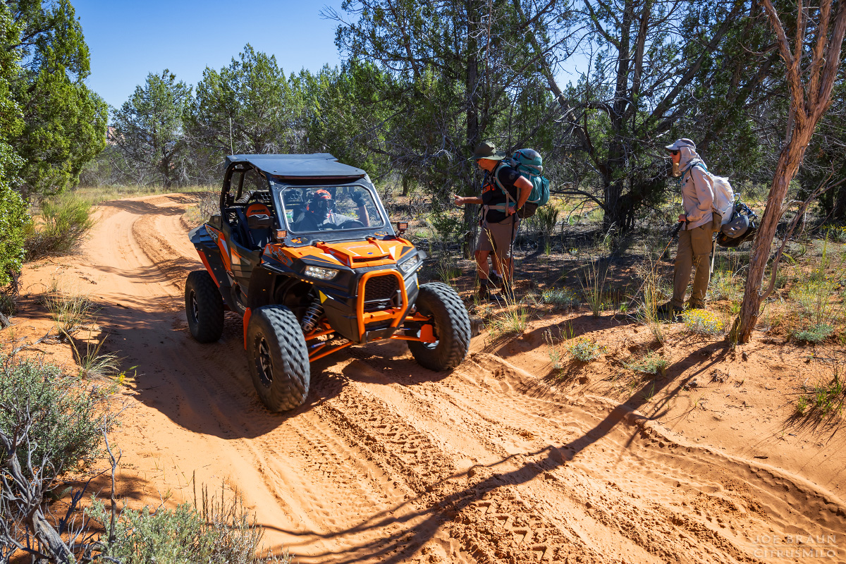
If you are visiting Rock Canyon as a day "hike", you will have to navigate the complex network of interconnected ATV trails located northwest of Coral Pink Sand Dunes State Park to get close to the southern rim of Parunuweap Canyon.
⚠ WARNING: These dirt roads have sections of deep sand and are intended only for offroad vehicles. If you drive a normal car here, you will likely get stuck and require rescue. Bring a good map of the roads and offline navigation aides to prevent yourself from getting lost on the wrong road.
Starting roughly 4 miles west of the Coral Pink Sand Dunes State Park entrance along CR 43 is the large Elephant Cove ATV Trailhead and parking area. From here, it is roughly 13 miles of driving on sandy ATV trails to get to the Rock Canyon Trailhead. Head north on Elephant Cove Road to Elephant Gap (the pass between the White Cliffs with Elephant Butte to the west). At 3.45 miles, veer left at the intersection to continue NW on Elephant Cove Road. At 8.47 miles, you will join up with Shunes Hollow Road for a bit and then at 8.77 miles, take the spur road north. This is BLM 18 (Rock Canyon/Barracks Overlook Trail). At 12.12 miles is the French Canyon TH and at 13 miles is the Rock Canyon TH.
The Route through Rock Canyon:
From the unmarked Rock Canyon trailhead, hike due south on the trail-of-use to the rim of Rock Canyon. Once at the rim, you can find a ramp to scramble down or you can hike the rim another few minutes to reach an easy walk-in spot.

Once in Rock Canyon, hike the sandy open wash downstream to get to the first rappel. Rappel #1 is a 50-ft drop with two potholes in front of it. Downclimb or do a short rappel off of bolts into the first pothole and climb out the far side to the second pothole. The potholes can be dry or have up to waist-deep water. Once out of the second pothole, the 50-ft rappel is off of two bolts in the left wall.
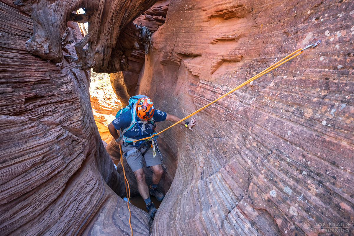

Just downcanyon is Rappel #2, a 100-ft tall V-shaped slope that can actually be downclimbed, but the start can be quite intimidating. My group started the rappel off of the bolts at the top and then about 30 feet down when it became obvious that we could downclimb the wedge safely, we got off of rappel and scrambled down the rest.

A few more moments downcanyon is Rappel #3, a short and easy 10-ft rappel off of bolts just before the big drop of the day, Rappel #4: a 115-ft rappel off of two bolts down into a beautiful grand alcove of sheer sandstone walls. Water may be trickling down the seeps. This is probably the most beautiful and stunning spot in the canyon and is a great place to enjoy a break before continuing down the canyon.

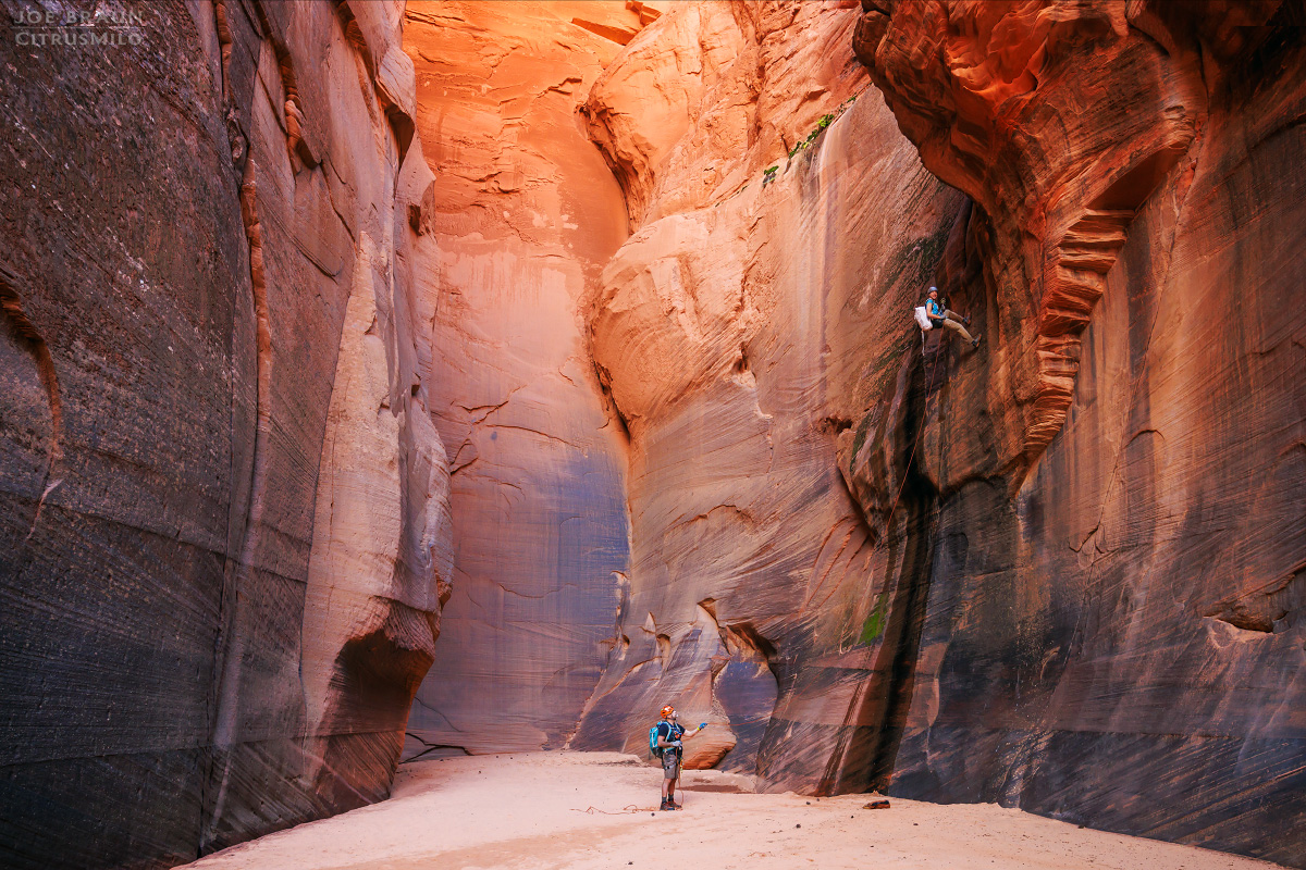
Beyond the grand alcove, continue hiking down this majestic section of canyon with its tall walls and flat sandy floor. After about half an hour of hiking, the canyon opens up and you reach the last Rappel #5: a 30-ft rappel off of two bolts over a sandstone lip. This marks the end of the technical section.

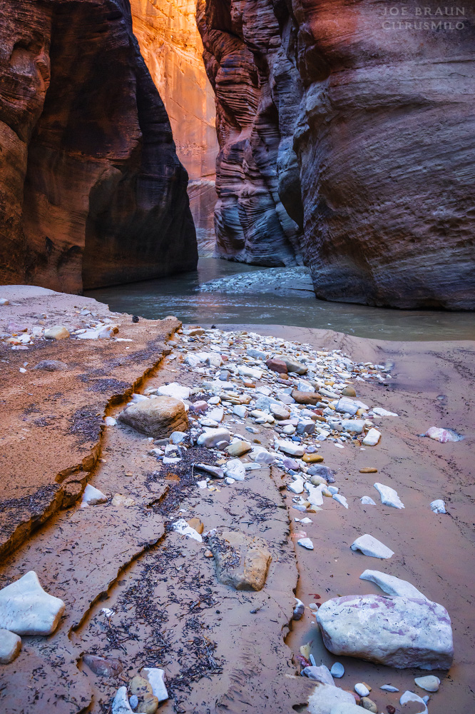
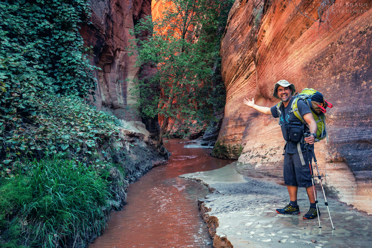
Continue hiking downstream to another narrow drop with an obvious walk-around and easy downclimb on the left. This is the start of the riparian section of Rock Canyon with flowing water and lush vegetation. Hike back up the lower seeps if you want to sneek a peak at the mini slot. Hike downcanyon another 15 minutes and you will be at the junction of Parunuweap Canyon (aka. the East Fork of the Virgin River).

Hiking down Parunuweap Canyon:
If you're looking to do the shortcut route, scramble up the southwest walls of the East Fork to hike up a ridgeline that leads to the ATV trail back to the Rock Canyon Trailhead. Personally, I think that a descent of Rock Canyon is a good excuse to visit the East Fork, so I would recommend doing the longer loop down Parunuweap and then exit up French Canyon.
The 2.5 mile stretch of canyon between Rock and French might not be the most dramatic section of the East Fork of the Virgin River, but there are a few very pretty sections of narrows that are worth seeing. After roughly 1.5 to 2 hours of hiking, you will pass the mouth of French Canyon on the left (south) side. UTM NAD27 coordinates: 336325mE, 4115708mN. French Canyon is easy to spot if you're looking for it; it's a very noticeable little slot with water flowing into the East Fork.
Hiking up and out of French Canyon:
French Canyon is relatively short and it can take less than an hour to make it to the top of the rim. Hike up the inviting little slot section of the canyon and it soon becomes densely vegetated; you will likely have to hike through a few knee-deep sections of the stream. Soon enough you reach the seeps and the canyon dries up. The head of the canyon is a beautiful amphitheater with impressive sandstone walls towering around you.
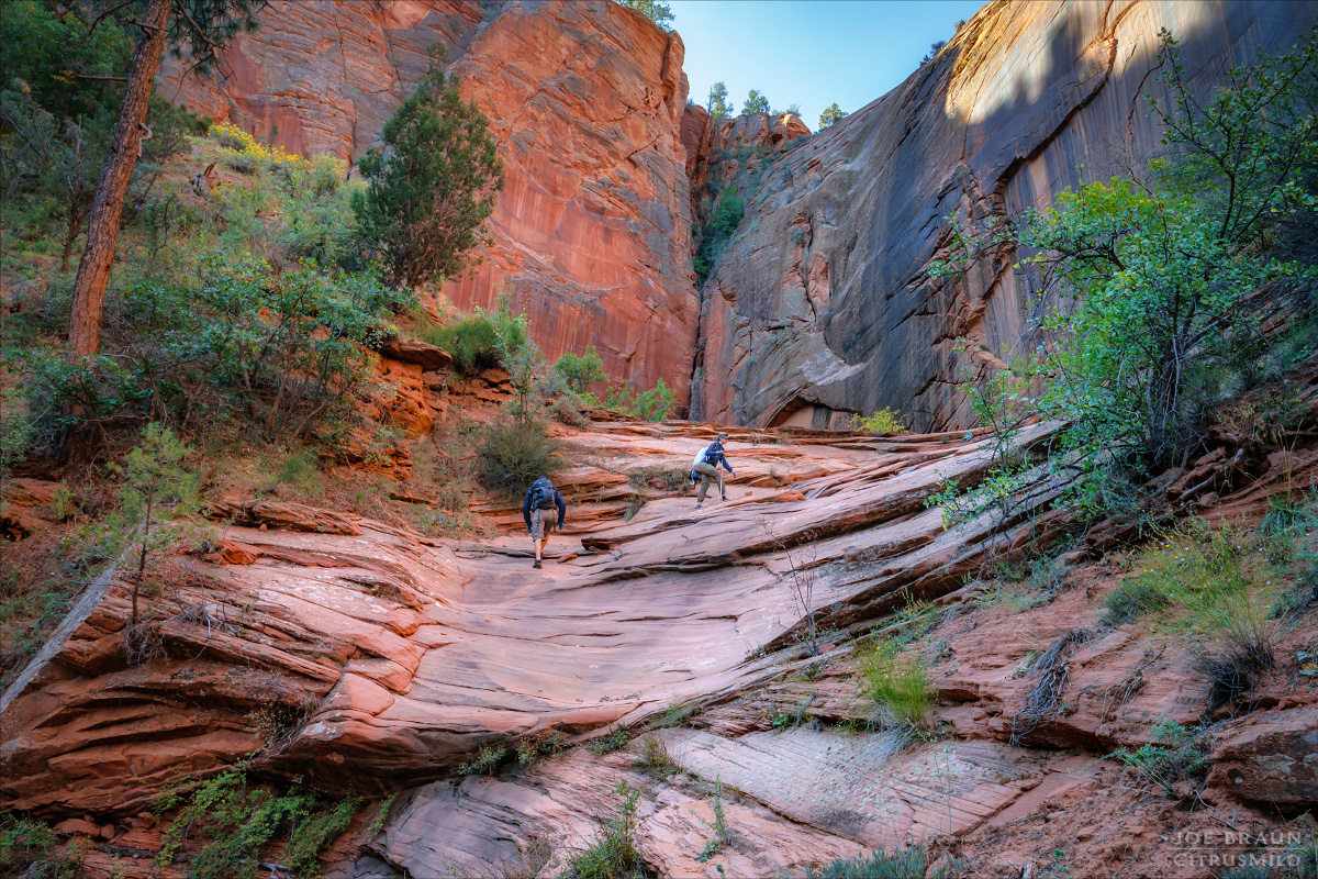
At the first alcove, find an easy walkaround trail-of-use on the right (west) side of the canyon to get to the shelves above. At the head of the canyon, look to the left (east) side of the canyon for another trail-of-use that heads up the sandy slopes to a fault line that allows you to scramble up and out of the canyon. The scramble is a bit strenuous, but not too technically difficult (class 2-3) and the terrain relents quickly enough.

Once you are standing on the east rim of the canyon, continue hiking south up the open ridgeline. You may follow a faint trail-of-use and stumble upon an old road, but even if you don't, if you head southeast, you will hit the main ATV road in short order. If your vehicle is parked at the Rock Canyon trailhead, continue east along the road for another mile to complete the loop.
Etymology of French Canyon:
I have to laugh and take credit for "French Canyon" getting its name even though I didn't directly name it. Back in 2003 when I posted photos of one of my hikes through Parunweap, I posed in front of the mouth of this canyon and jokingly wrote the caption: "I claim this side canyon in the name of France!"
Tanya Milligan (co-author of the book "Favorite Hikes in and around Zion National Park") kept jokingly referring to this canyon as "Joe's French Canyon" because of my photo and the name has amusingly stuck over the years. I suppose the name could also be a metaphor for French military retreats since this canyon is used to escape out of Parunuweap.
Joe's Spin:
I absolutely love the loop hike up French Canyon and down Rock Canyon as part of an extended trek through Parunuweap Canyon. The route takes you through some truly beautiful scenery that is simply too difficult and remote to interest most people. The downside of this route though is carrying canyoneering gear and 200 feet of rope through Parunuweap, especially when it's time to go up the long uphill Checkerboard Mesa exit route, but those exhausting memories easily fade with time!

