

A Fun Canyoneering Adventure:
Located on BLM land near the eastern boundary of Zion National Park, Birch Hollow is a usually dry tributary of Orderville Canyon and it makes for an enjoyable canyoneering adventure with its convenient start right along the North Fork Road. The route through Birch Hollow is only two miles in length, but with roughly 11 rappels up to 100 feet, this fun little adventure should be taken seriously. Birch Hollow has gained quite a bit of popularity over the past decade and as such, most of the drops are now bolted and many guiding services take people through this canyon. Please obey all posted rules at the trailheads to guarantee continued access in the future.
⚠ WARNING: This route is not suitable for hikers who have no technical canyoneering experience.
Logistics:
Birch Hollow is located entirely on BLM land and as such, you do not need a Zion National Park canyoneering permit to do this canyon if you plan on exiting up Orderville Canyon. If you plan on continuing down Orderville Canyon into Zion National Park to the Zion Narrows and the Temple of Sinawava, you DO need a Zion canyoneering permit for Orderville Canyon. Complete info on the NPS canyoneering permits page. A shuttle service from one of the Springdale outfitters to the trailhead is extremely convenient, especially if you are planning to hike out the Narrows. If you have two cars and plan to exit up Orderville Canyon, spotting one car at the Orderville Canyon Trailhead will save you a good amount of road walking.

While Birch Hollow is a fairly straightforward canyon, many inexperienced canyoneers descend this canyon and there have been several accidents from very basic mistakes: rappelling off the end of a rope that was set too short, getting a hand caught between the rock and rope and letting go with the rappelling hand to try and fix, and somebody getting off rope during a two-person simul-rappel. Be safe and be careful.
The Approach Hike and the Two Bowls:
The roadside trailhead is located 8.5 miles up the North Fork Road from Route 9 right where the road crosses the Birch Hollow wash. A billboard sign marks the spot and there is room for a few cars to park; please obey all posted rules. From the sign, follow a trail-of-use down into the wash and simply hike down the wash, working your way around a few minor obstacles.

Along the way, you will encounter an old wooden ATV bridge and after roughly 45 minutes and almost a mile of hiking, you will get to the first significant obstacle: a large bowl where the canyon drops dramatically through many broken layers of rock.
Rappel 1--The First Bowl (30 feet): While a rappel right down the center would probably be about 120 feet, walk the rim to the right (east) to a convenient and much shorter rap off of a tree. The layers of rock in this section are loose so don't kick any debris onto your partners. (Alternatively, you can also scramble down the left/south side of the canyon without having to rappel, but I prefer doing this little warm-up rap.) Once down the rockslide, continue hiking the wash for another 10 minutes to a second large bowl...

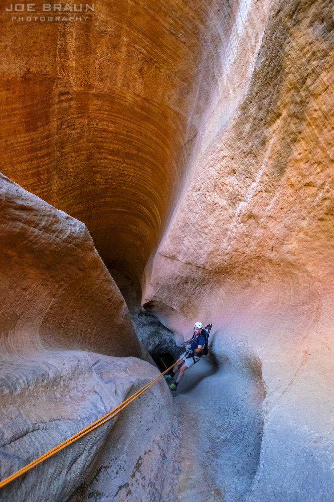
Rappel 2--The Second Bowl (60 feet): The anchor will likely be webbing around a fallen tree or one of the boulders a bit back from the lip. (You will need to use more than 60 feet of rope to reach the ground.) The start of this rap is a bit awkward and can be intimidating to newbies; don't flip over backwards and don't let go with your rappelling hand. Once down, you are now in the slot section and it's time for some fun.

The Upper Slot:
Continue hiking down this much narrower and photogenic section of canyon past a few minor obstacles to get to a series of three very short rappels. Rappel 3 (10 feet) off of bolts on the right, followed by Rappel 4 (15 feet) off of two bolts on the left), then right after, Rappel 5 (25 feet) off of two bolts on the right. The canyon then dramatically changes mood as it widens into a beautiful dark forested area. Soon enough, you reach an open section where the canyon drops dramatically down a chute below.
The Lower Slot:
Rappel 6--The Long Chute (100 feet): This is the rappel of the day that will get your attention. The anchor should be on a tree on the left (south) side sending you down the chute; this is a fun and long drop!

Once down, keep the rope out because Rappel 7 (45-feet) is right around the corner off of two bolts in the right wall, going down another beautifully-sculpted chute. And a stone's throw away is Rappel 8 (45-feet), another straight-forward rap off of two bolts on the right down another chute.

Hike downcanyon a bit and downclimb a little 8' tall boulder obstacle and just beyond is Rappel 9 (35-feet) off of two bolts on the right down yet another chute that usually has a good collection of logs at the bottom. Right around the corner is the grand finale...
Rappel 10--The Chockstone Room (70 feet) down a dark chute that almost feels like a cave; this is the chockstone room! Look up to see the giant boulder wedged between the walls far above; this is probably the prettiest spot of the canyon.

The last drop is from this room: Rappel 11 (40 feet) down the beautiful fluted drop to the bottom of the canyon. (Great action shots of your friends can be taken from the top or bottom of this rap.) Once at the bottom of the last rap, hike a few sections to the junction of Orderville Canyon!
The Hike Out:
If you're planning on hiking up out of Orderville Canyon, turn right (east) and head up the canyon. It's about a two-hour hike out the Orderville dryfall and up the dirt road to your car (or much closer if you have a 4WD vehicle that can make it to the end of the rough road). If you're planning on hiking down Orderville Canyon and out the Zion Narrows (the much more fun, but longer options), be prepared for two more very short rappels, a lot of downclimbs, and a lot of getting wet!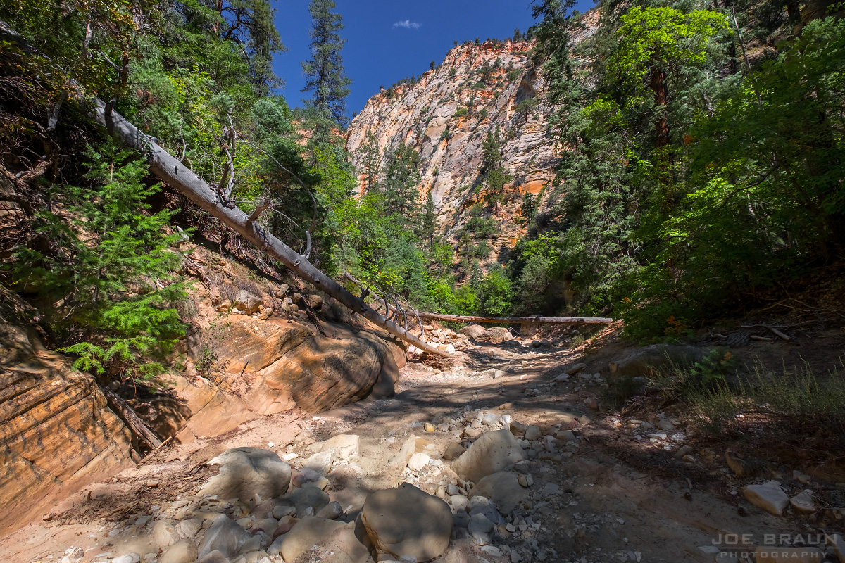
Joe's Spin:
How could anybody not like this hike? Great canyon scenery, fun rappels, and nothing too difficult or epic about this route. The only downside perhaps is how popular this canyon is, especially with guided tours. Do your best to minimize your impact and please allow faster parties to play through so that everybody can enjoy this canyon at their own pace.

